AUTUNNO TRA I TACCHI – OSINI – 7-8 DICEMBRE 2013FALL IN THE HEELS – OSINI – DECEMBER 7 TO 8
 AUTUNNO TRA I TACCHI
Altro evento in collaborazione con il Comune di Osini curato da Magia dei Tacchi nel suo programma di animazione turistica e culturale, e questa volta aggiungiamo scientifica, nella Valle del Pardu.
Sarà un evento a cavallo tra scienza, tradizioni e ricordi che lega l’alluvione del 51 a quella del Novembre 2013.
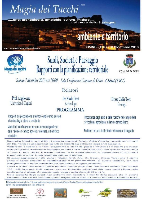
Sabato alle ore 16 presso il Comune di Osini convegno su Suoli, Società e Paesaggio e i rapporti con la Pianificazione Territoriale. Tema più che mai attuale. Un occasione per amministratori pubblici, operatori del territorio, ordini professionali per dialogare di problematiche sempre più attuali.
Relatori il Prof. Angelo Aru, Dr. Nicola Dessì archeologo, la dr.ssa Clelia Tore geologo.
Domenica 8 andremo a visitare i paesi fantasma di Osini e Gairo Vecchio, costruiti sui versanti del Rio Pardu ed abbandonati da tutti gli abitanti già dall’inizio degli anni sessanta.
Visiteremo le strade e le case, scopriremo la storia dei paesi e rivivremo i momenti più intensi della più grande alluvione in Sardegna di tutto il ‘900: quella del 1951 che spazzò via centinaia di case in tutta l’isola. Il nostro realismo e la vostra fantasia ci permetteranno di trovarci veramente in questi luoghi tornando indietro di 60 anni.
Ci accompagneranno nella visita i relatori (prof. Aru, Dr. Dessì, Dr.ssa Tore) che il giorno prima ci hanno illustrato le caratteristiche e le problematiche di questo territorio, con loro dialogheremo in modo conviviale ma con metodo e rigore scientifico.
Ospiti e guide d’eccezione quelle persone, avanti negli anni, che hanno vissuto quel terribile 1951 dalle loro voci, testimonianze (spesso il dialetto ogliastrino) rivivremo questi villaggi nella quotidianità di allora. Un emozionante viaggio nella storia di 60 anni fa.
Nella casualità degli eventi non potremo non ricordare il monito della natura che in questo Novembre 2013 ci ha ricordato quanto fragile possa essere il nostro territorio e la nostra Isola.
Cronaca della più grande alluvione del ‘900 in SardegnaLa alluvione del 14-19 ottobre del 1951, presenta i suoi aspetti di eccezionalità prevalentemente per la estensione dei fenomeni violenti che hanno flagellato ininterrottamente, per 6 giorni quasi tutta l’isola. La durata dei fenomeni, che si perpetrarono con intensità eccezionale, nell’arco di tutte le 24 ore della giornata, per 3-4 giorni, portando accumuli giornalieri diffusamente superiori ai 400 mm, con picchi di oltre 500 mm. Quantitativi giornalieri superiori ai 300-500 mm, per le località centro orientali della Sardegna, presentano un tempo di ritorno molto inferiore rispetto alle altre località dell’isola,
Martedì 15 ottobre 1951:Nella costa orientale la pioggia continua con intensità sempre crescente. Alle ore 12 il Flumendosa è in piena controllata, 416 mm Genna Crexia 395 mm Arzana 350 mm Baunei
Mercoledì 16 ottobre 1951: San Vito è parzialmente inondato dalle acque. Alle ore 8:30 del mattino, il lago dell’alto Flumendosa, che il giorno prima conteneva poco meno di ¼ della capacità massima, raggiunge il livello di massimo invaso e si comincia a scaricare l’acqua in eccesso a valle.
417 mm Genna Crexia 400 mm Arzana
Giovedì 17 ottobre 1951:
Centinaia di case travolte nei paesi del basso Flumendosa. Il ponte che attraversa il Flumendosa e che collega Villaputzu a San Vito, si presenta intatto nonostante sia stato scavalcato dalle acque per un altezza pari a 15 cm (secondo i rilievi dell’ente idrografico sardo). Nonostante il ponte non sia crollato, la strada è impraticabile, per la mancanza di 150 metri di manto stradale verso Muravera e di 70 metri circa nel lato di Villaputzu
Nella parte centro orientale dell’isola, la pioggia continuava con la stessa intensità dei giorni precedenti e in alcuni casi il 17 risultò il giorno più piovoso dell’intero mese. 371 mm Jerzu 365 mm Arzana
Venerdì 18 ottobre 1951:
E’ una giornata di transizione, la pioggia prende a cadere su quasi tutta l’isola con una intensità definibile eccezionale,. Interrotta pure la linea ferroviaria Ussassai-Arbatax, per il crollo di una galleria. Si ha poi il primo bilancio dei paesi rimasti isolati: Oliena-Arzana-Baunei-Gairo-Jerzu-Loceri-Tortolì-Talana-Nuoro. In questi giorni i rifornimenti per le località isolate vengono mandati tramite aerei, che paracadutano casse di viveri verso i paesi isolati.
257 mm Jerzu
Sabato 19 Ottobre 1951:
Finalmente nella giornata del 19 la Sardegna esce dal raggio di influenza della depressione anche se fino al tardo mattino continuano a registrarsi piogge talora intense. E’ il momento di contare i danni. Muravera, San Vito, Buddusò, Villaputzu sono le frazioni più colpite con centinaia di case crollate e migliaia danneggiate. Le vittime restano ferme a 5. Centinaia di strade sono interrotte, decine di ponti crollati, dei paesi non sono ancora raggiungibili, si scoprirà solo in seguito che alcuni sono stati completamente distrutti e verranno abbandonati diventando dei paesi fantasma come Osini e Gairo (in foto) . Un terzo del territorio isolano è stato duramente colpito, è l’alluvione peggiore del secolo.
Per info: magiadeitacchi@gmail.com
Cell. 3939701850FALL BETWEEN THE HEELS
Another event in collaboration with the Municipality of Osini edited by Magic of Heels in its program of cultural and tourist activities , and this time add scientific , in the Valley of Pardu .
It will be an event in horse science , traditions and memories that binds the flood of 51 to that of November 2013 .
Saturday at 16 pm at the City of Osini Conference on Soils , Society and Landscape and the relationship with the Regional Planning . Topic more timely than ever . An opportunity for public administrators, local operators , professional to talk to more current issues .
Speakers Prof. Angelo Aru , Dr. Nicola Dessi archaeologist , Dr. Clelia Tore geologist .
Sunday 8th we will visit the ghost towns of the Old Osini and Gairloch , built on the slopes of Rio Pardu and abandoned by all the inhabitants since the early sixties.
We will visit the streets and houses , we will discover the history of the country and we will relive the most intense moments of the largest flood in Sardinia of all the 900 : the one of 1951 that swept away hundreds of homes across the island . Our realism and your imagination will allow us to really find in these places going back 60 years.
We accompany you on your visit to the speakers (Prof. Aru , Dr. Dessi , Dr. Tore ) that the day before we were shown the characteristics and problems of this country, with their dialogheremo so friendly but with method and scientific rigor.
Guests and exceptional guides those people, advanced in years, having lived through that terrible 1951 by their voices , testimonies (often the dialect ogliastrino ) will relive these villages in everyday life back then. An exciting journey through the history of 60 years ago.
The randomness of events we can not recall the admonition of nature in this November 2013 reminded us how fragile it can be our territory and our Island .
Chronicle of the biggest flood in 900 SardegnaLa flood of October 14 to 19 , 1951, presents its exceptional aspects mainly to the extent of violent phenomena that have plagued continuously , for 6 days almost the whole island . The duration of the phenomena , which were perpetrated with exceptional intensity , all within 24 hours of the day, for 3-4 days , bringing the daily accumulations diffusely in excess of 400 mm , with peaks of more than 500 mm. Daily quantities greater than 300-500 mm for the eastern and central location in Sardinia, have a return period much lower compared to other resorts on the island ,
Tuesday, October 15, 1951 : On the east coast the rain continues with increasing intensity . At 12 o’clock the Flumendosa is in full control, Genna Crexia 416 mm 395 mm 350 mm Arzana Baunei
Wednesday, October 16, 1951 : San Vito is partially flooded by the waters . At 8:30 am, the high lake Flumendosa , the day before contained a little less than ¼ of the maximum capacity, reach the maximum water level and you begin to drain the excess water downstream .
Genna Crexia 417 mm 400 mm Arzana
Thursday, October 17, 1951 :
Hundreds of houses swept away in countries of low Flumendosa . The bridge that crosses the Flumendosa and linking Villaputzu in San Vito , is intact despite having been overtaken by the water to a height of 15 cm (according to the findings of the institution Sardinian basin ) . Although the bridge has not collapsed , the road is impassable due to the lack of 150 meters of road towards Costa Rei and 70 meters into the side of Villaputzu
At the center of the island, the rain continued with the same intensity of the previous days and in some cases the result was the 17th wettest day of the entire month. 371 mm 365 mm Jerzu Arzana
Friday, October 18, 1951 :
It ‘ a day of transition , the rain starts to fall on almost the whole island with an intensity defined exceptional . Also interrupted the railway line Ussassai -Arbatax , for the collapse of a tunnel . It was then the first budget of the country remained isolated Oliena – Arzana – Baunei – Gairloch – Jerzu – Loceri – Tortoli- Talana – Nuoro. These days the supplies to remote areas are sent by air , parachuting crates of food to landlocked countries .
257 mm Jerzu
Saturday, October 19, 1951 :
Finally the day of the Sardinia 19 out of the range of influence of depression although until the late morning sometimes intense rains continue to register . It ‘s time to count the damage. Rei, San Vito , Buddusò Villaputzu are the most affected villages with hundreds of houses collapsed and thousands injured . The victims remain stuck at 5 . Hundreds of roads are blocked , dozens of bridges collapsed , countries have not yet reached , you will discover only later that some were completely destroyed and abandoned are becoming ghost towns as the Osini and Gairloch (pictured) . One third of the island territory has been severely affected , it is the worst flood of the century.
For info: magiadeitacchi@gmail.com
Cell 3939701850


Leave a Comment
You must be logged in to post a comment.
